

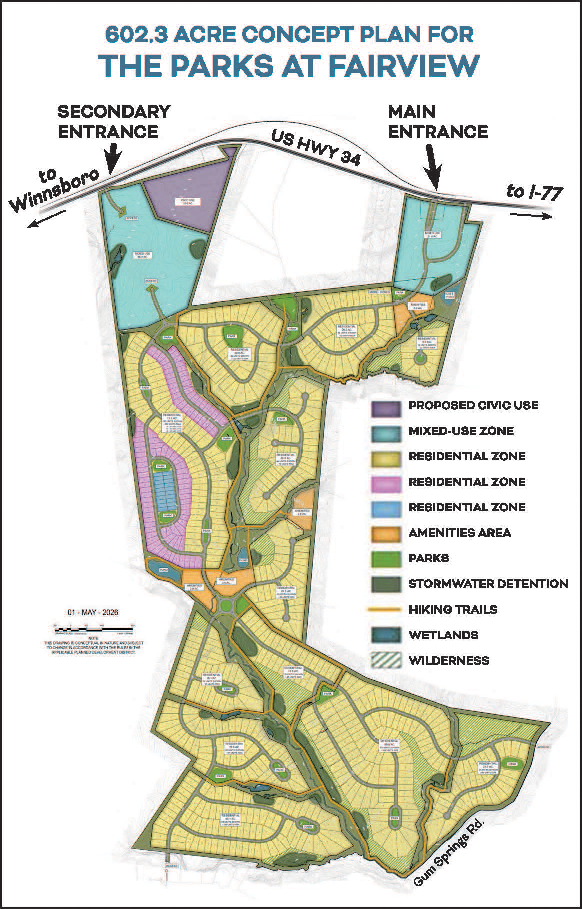
WINNSBORO — A mixed-use development that could bring up to 1,650 homes and commercial space to Winnsboro has cleared its final municipal hurdles.
During a special-called meeting on Tuesday, Sept. 29, the Winnsboro Town Council voted to approve second and final reading of an ordinance rezoning approximately 602.3 acres along Highway 34 from R-1 (Single-Family Residential) to PDD (Planned Development District).
In a concurrent vote, council also approved a formal development agreement between the Town of Winnsboro, property owners Timberland Assets LLC and Tern II Assets LLC, and developer Tru-Scout Properties LLC.
The project, officially designated as The Parks at Fairview, sits near Gum Springs Road, just off Highway 34. Developers highlighted the site’s strategic location—situated along major commuter corridors within reach of Columbia, the V.C. Summer Nuclear Station, and the emerging Scout Motors manufacturing plant—as a primary driver behind the investment.
Winnsboro Town Manager Chris Clauson noted the Highway 34 corridor has long been positioned for growth.
“This development is, I think, a great sign of the kind of residential development we’ve been waiting for and anticipating,” he said, “and, it’s the reason why we went under a moratorium and took the time to listen to the community and find out what they wanted. We think this development is in line with what they want and what we’ve prepared for.”
The Property & Concept Plan
The development encompasses four parcels, three of which were annexed into town limits in July, while a fourth tract was annexed in 2023:
- A 575-acre tract (TMS No. 165-00-01-005-000)
- A 24.51-acre tract (TMS No. 165-00-011-000)
- A 1.82-acre tract (TMS No. 165-00-01-030-000)
- A 0.78-acre tract (TMS No. 165-00-01-031-000)
Winnsboro’s Planning Commission first recommended approval of the rezoning application following a July 2 review.
Under the approved PDD guidelines, the property is split into two primary zones:
Residential Zone: Slated for up to 1,050 residential units, configured into neighborhood “pods” featuring single-family detached homes, townhomes, duplexes, and multi-family communities.
Each pod is planned to incorporate neighborhood parks and recreational space.
Mixed-Use Zone: Slated for up to 600 residential units (including apartments and multi-unit housing) alongside 150,000 square feet of commercial and retail frontage.
The approved land-use distribution for the 602.3 acres includes:
- 401.2 acres of residential use
- 112.9 acres of designated open space
- 50.9 acres of mixed-use (commercial and retail)
- 15.0 acres of proposed civic use
- 12.3 acres of dedicated amenities areas
Lot Sizes and Development Standards
According to the PDD document, single-family detached homes will have a minimum lot size of 5,000 square feet with a minimum 40-foot width at the setback line. Single-family attached townhomes will have a minimum lot size of 2,160 square feet, with a maximum of six units connected in a continuous row.
In the mixed-use district, multi-family housing (such as apartments) is capped at 20 gross acres. However, residential units constructed directly above ground-floor retail or commercial storefronts will not count toward that 20-acre cap.
Road Access and Traffic
The master plan outlines between two and four direct access points onto Highway 34, along with one access point each on Roddy Road and Gum Springs Road. A comprehensive master traffic study will be submitted to the town and the S.C. Department of Transportation before the first phase begins, with required updates every three to five years.
Civic Dedication, Parks, and Buffers
The 15 acres earmarked for civic use are planned to be dedicated to the Town of Winnsboro for public facilities—such as school, fire, or police services—in alignment with the town’s development impact fee ordinance.
The plan mandates that at least 20% of the gross acreage (over 120 acres) remain open space, with each residential pod required to feature at least one park within walking distance. In addition, the development must maintain a 50-foot perimeter buffer along its residential boundaries and a 20-foot landscaped buffer along Highway 34. All electric, gas, water, and sewer lines will be placed underground.
Timeline and Next Steps
With the rezoning and master development agreement officially approved, the development team will now proceed with technical due diligence, including conducting required traffic impact studies on adjacent roadways.
The developer will subsequently submit preliminary and final site plans, engineering documents, and subdivision plats to town staff and the Planning Commission for administrative review.
Project representatives estimate that infrastructure permitting, engineering, and initial site work will take one to two years, with the first phase of homes anticipated within roughly two years. Complete buildout of the 1,650-unit community is projected over the next 10 to 12 years.